The 2018 Whangamata Adventure Race took place from a base in Opoutere, not far north of Whangamata. The 12 hour race included 5 stages in a loops format from the start finish. Our team, Ataraxia, included myself, Hannah Lowe, Mat Morreau and Will Hand. Will was a late call up after an injury, but over the course of the day showed his strength and wide range of skills.
The opening stage was essentially orienteering, with teams having to collect 420 points in from an array of controls worth a total of 560. The terrain was a new map of the coastal pine forest, complete with orienteering symbols. It sounded like an awesome way to start an adventure race, and potentially great for our team. Naturally, I proceeded to completely stuff up the first control, taking the usual headless chicken approach to the race. Around the mid point of the course I also made what is sometimes called an admin error, and started navigating to the wrong control. After figuring out my error it meant we had to slightly adjust our planned route to ensure we had the necessary 420 points. To further add unnecessary stress I forgot which controls we had been too, leading to some hurried mental addition en route to transition. Despite all of this we arrived in TA1 with the front little pack of teams.
From TA1 we set out onto the Opoutere Estuary in kayaks. The dawn glow and slowly rising sun made the views out over the estuary mouth one of the highlights of the race. We made good pace around the paddle loop, with around 5 – 6 teams all quite close together and not really able to get much separation in the flat waters of the estuary. Things were still pretty close into transition, a good push to get through quickly and out onto stage 3, a short mountain bike. Our pace was solid on the ride, we made good time and flowed well through controls. After some initial glances over the shoulder we settled into our own race, keen to be steady and avoid further silly errors from trying to rush ahead of other teams.
The main stage of the race was the trek of stage 4. This began with a coastal section before heading up into the plantation pine forestry and north to Pauanui. Ryan had mentioned a significant bush bash at the pre race briefing. What we found early in the stage was a pleasant surprise. As we were behind the 12 hour non kayak teams and the 6 hour teams we had an excellent human sized trail to follow up the first hill. The main bash down to Storm Beach and controls 24 and 25 also included a number of sections that had pre made trails through the bush. That being said, the line of many of these tracks went a long way right, and ultimately towards some steep, bluffy looking terrain. We got our share of pushing through raw forest trying to head back to the left and find a better line down to the beach. In the last couple of hundred meters, we could see and hear other teams also trying to make similar progress towards the beach. Control 24 was a stunner, it required a short swim up a narrow gorge for 8-10m, to reveal an awesome water fall just around the corner. The chilly swim was definitely worth it.
Hannah set a cracking pace for us back up to the trig from Pauanui. Looking back at the tracker data we were approximately 20 minutes ahead at this point in the race, though at the time we had no idea of time gaps, having not seen any 12 hour kayak teams since departing kayak transition. The rest of the stage included some off track checkpoints in the forestry. We tried to travel as much as possible on the roads due to the much better rate of travel. While some of the forestry was reasonable there were also areas of very slow thinned trees and significant undergrowth.
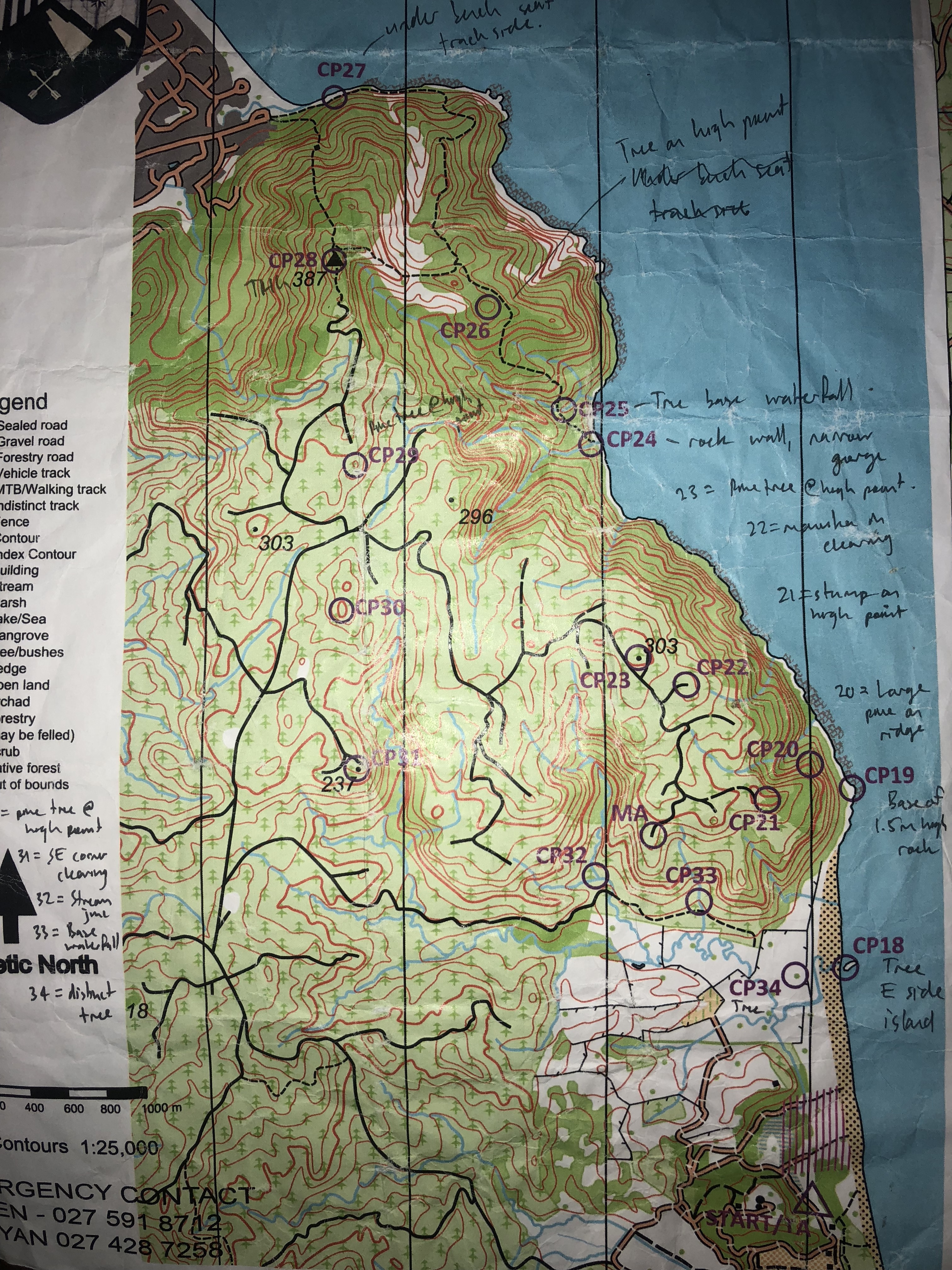
We took off on the final stage with the optimistic goal of finishing in daylight. We quickly got through the first part of the course and reached the main route choice problem of the leg, “dilemma hill”. Option 1 included a backtrack and a loop around the hill, sticking to the roads. Pros were minimal bush bashing, cons included added distance and climb. Option 2 was to follow the road up towards point 327 from CP39 and bush bash high along the spur, hoping for an old track or nice travel. Option 3 was a long shot, but involved heading down the hill and south west from the control to the road end just south of CP 40 for a short, but uphill bush bash.
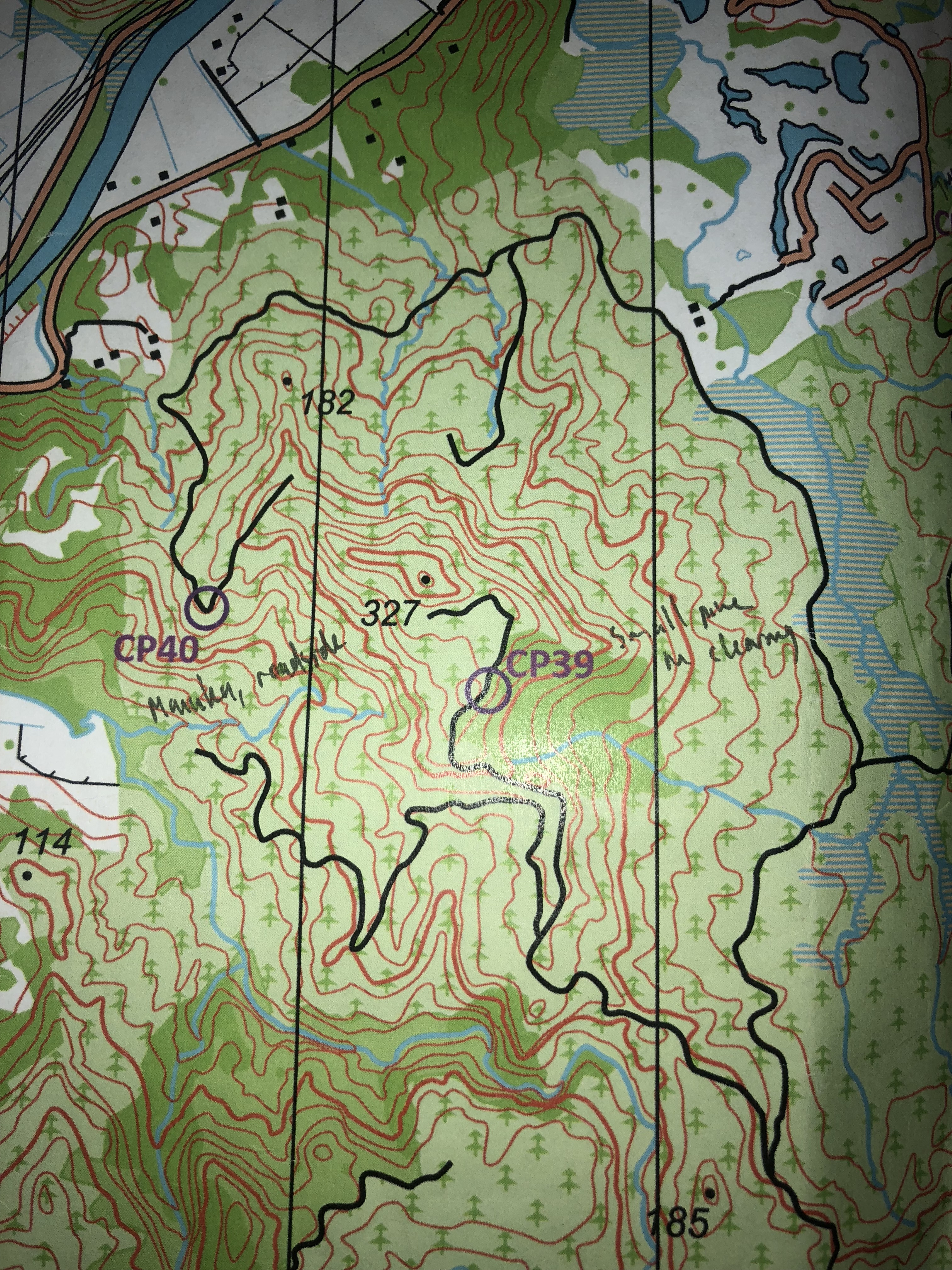
We debated back and forth on the climb up the hill. By the time we gained the height to CP39 we figured we should at least look for a track. At the end of the road there was a small clearing, an old logging platform perhaps, with a quite welcoming indistinct path heading into the forest in the direction we wanted to travel. Our choice was made, option 2 it would be. The first part up to the spur was fine. We gained the hill top approximately at the end of the index control. The travel on the ridge got a little worse, but was ok, thicker vegetation but still generally passable. Once we started to lose height, things got worse. The forest had been thinned, so a route had to be negotiated over many fallen trees, complete with slippery trunks and branches waiting to catch wheels and derailleurs. Mercifully the track at the other end did exist and we were able to easily find CP40. After riding back around the hill to get to CP41, we felt we had made the right choice, as the road was rather rough and did include some steep-ish pinch climbs that would have slowed our progress.
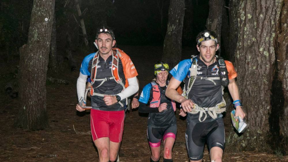
The rest of the stage was pretty smooth, some cool singletrack and reasonably straight forward navigation had us arriving back at the finish at around 12 and a half hours. We didn’t manage our goal of finish before dark and had to don the headlamps for the final hour or so.
Overall it was another great race from Ryan, Bex and the rest of the Whangamata AR crew. Our team kept moving well throughout the day, with everyone looking after themselves enough to keep the pace moving right to the end. A special mention must be made of Will, who rode on flat pedals for the race on a borrowed bike. Despite the lack of clip pedals we couldn’t drop him! Perhaps we will have to get the team back together for the Marakopa Munter in October.
If you raced Whangamata and went home with legs that were cut up and scratched from time spent off track, then take a look at www.grassyknoll.co.nz and the Trimtex Gaiters and O pants. Originally designed as orienteering gear, they are ideal for adventure racing. Just take a loop at the top teams racing at Godzone or ARWS events and you’ll see the Trimtex gaiters and pants.
![]()
